A four-member delegation from India's Jal Shakti ministry is heading to Dhaka for the 91st meeting of the India-Bangladesh Joint Committee on the treaty, set for 21 to 23 November 2026. According to ThePrint, citing government sources, extending the Ganga Water Treaty, which lapses on 12 December, will not be on the official agenda. The easy read writes itself. India sits upstream, holds the barrage at Farakka, and has three weeks of leverage over a neighbour that depends on what it lets through.
That read treats the treaty as a contest over a fixed quantity of water. It is worth slowing down on that. The quantity was never fixed, and the one the treaty assumed is not the one the river now carries.
The guarantee was sized on a wetter river
The 1996 treaty text, signed in New Delhi on 12 December 1996, runs for thirty years and can be renewed only by mutual consent. Its core is a lean-season formula. Per Annexure I of the treaty, when flow at Farakka is below 70,000 cusecs the water is split 50:50, and between 11 March and 10 May each country is guaranteed 35,000 cusecs in alternate three 10-day periods. Above 75,000 cusecs, India takes 40,000.
The squeeze is visible in the treaty's own schedule. Annexure II, built on average flows for 1949 to 1988, puts every 10-day block from 11 March to 10 May below 70,000 cusecs. The schedule runs from 68,931 cusecs in 11 to 20 March down to 60,992 in 21 to 30 April. In that late-April block, on average flows, a guaranteed 35,000 cusecs for Bangladesh leaves India 25,992.
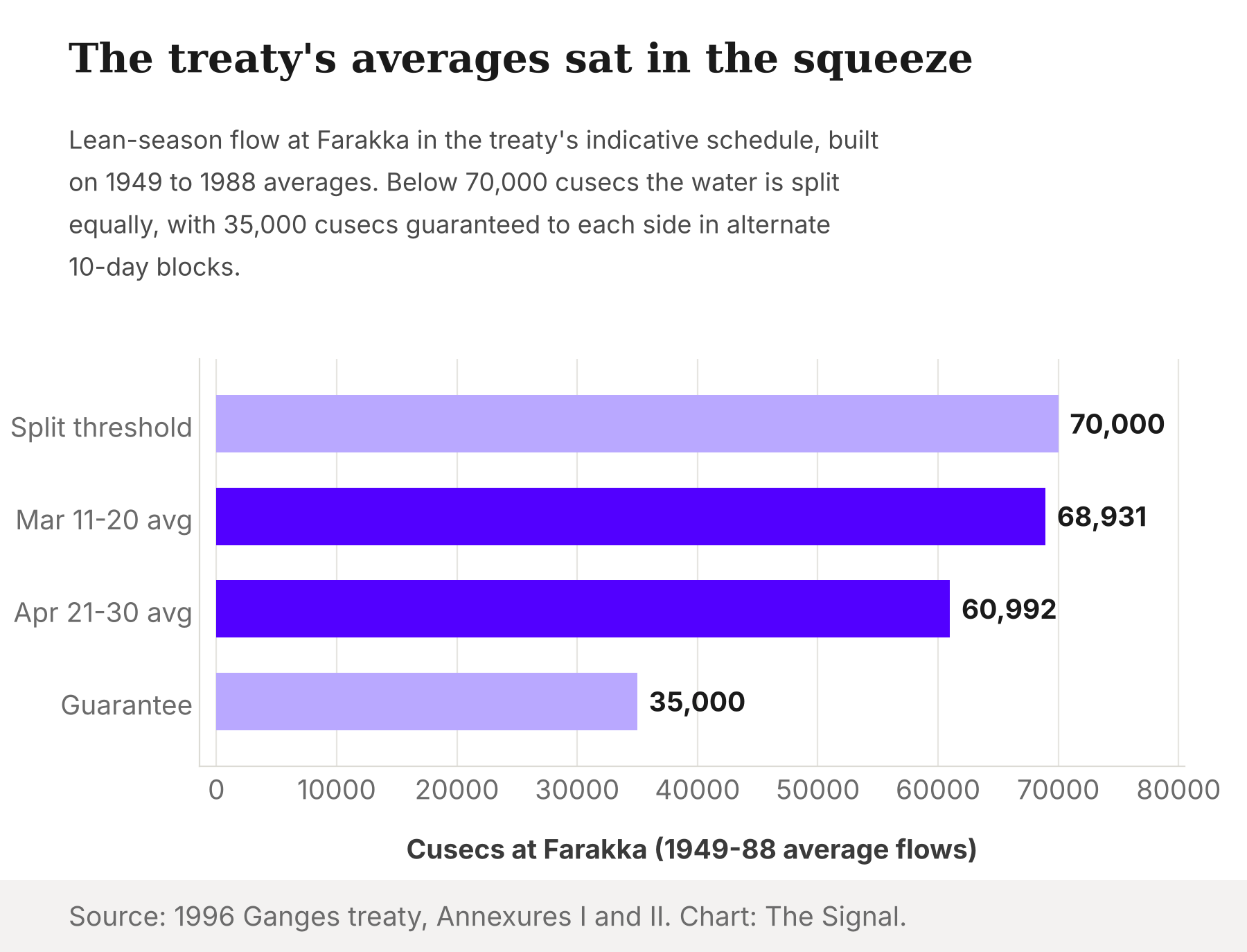
So even in 1996 the formula was designed for scarcity. The guarantee works by handing one side 35,000 cusecs in turn when there is not enough for both. The treaty's Article II adds a tripwire: if flow at Farakka falls below 50,000 cusecs in any 10-day period, the two governments must consult immediately. Every one of those thresholds was set against the 1949-88 averages.
The river did not stay at its averages
The decades since have not looked like that baseline. A 2025 peer-reviewed PNAS study by Chuphal, Thirumalai and Mishra finds that Ganga streamflow at Farakka in 1991-2020 was the driest in 1,300 years, and that the decline since the 1990s is 76% more intense than the 16th-century drought, its closest historical analogue. The study attributes the decline mainly to weaker monsoon rainfall, with groundwater pumping a contributing factor.
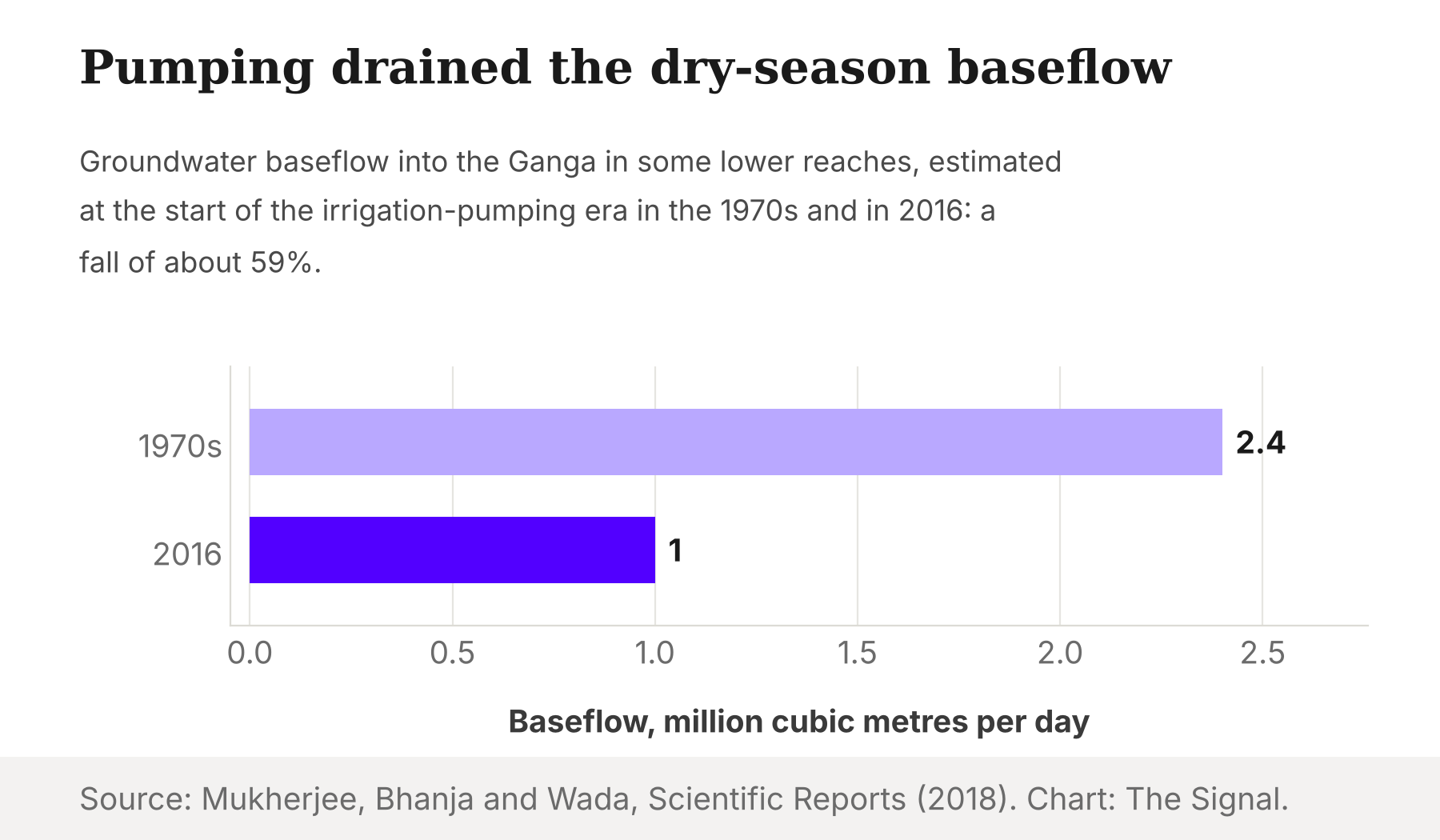
That ordering matters for anyone who wants a villain. The main driver in the PNAS reconstruction is the sky, which neither Delhi nor Dhaka controls. Pumping, the lesser factor, happens on India's side of the border. A 2018 study in Scientific Reports by Mukherjee, Bhanja and Wada estimates that groundwater pumping cut dry-season baseflow into the Ganga in some lower reaches by about 59%, from 2.4 million cubic metres a day at the start of the irrigation-pumping era in the 1970s to about 1.0 million by 2016.
India's own states argue over the same shortfall. A Bihar State Pollution Control Board document, reported by Mongabay-India in October 2026, puts the river's February-to-April flow at Chausa, where it enters Bihar from Uttar Pradesh, at just 400 cusecs, against about 1,600 cusecs at Kahalgaon downstream. Bihar has demanded 2,000 cusecs for itself, five times what the document says arrives at its border in the lean months.
The port's claim on the water has not shrunk
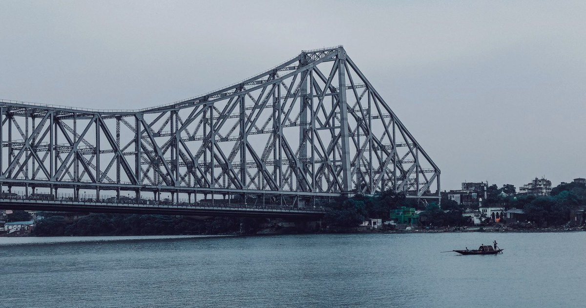
The other half of the old bargain is India's reason for diverting water at all. As The Week reports, citing the Farakka Barrage Project, the barrage was built to push Ganga water into the Bhagirathi-Hooghly system and keep Kolkata Port navigable.
A tempting argument says that reason has faded, because most of the port's cargo now moves through Haldia, nearer the sea. The share is real. Ministry of Ports, Shipping and Waterways data for April-March 2025-26, advance estimates, show Syama Prasad Mookerjee Port handled 70.70 million tonnes, with the Haldia Dock Complex at 51.86 million (about 73%) and the Kolkata Dock System at 18.84 million (about 27%).
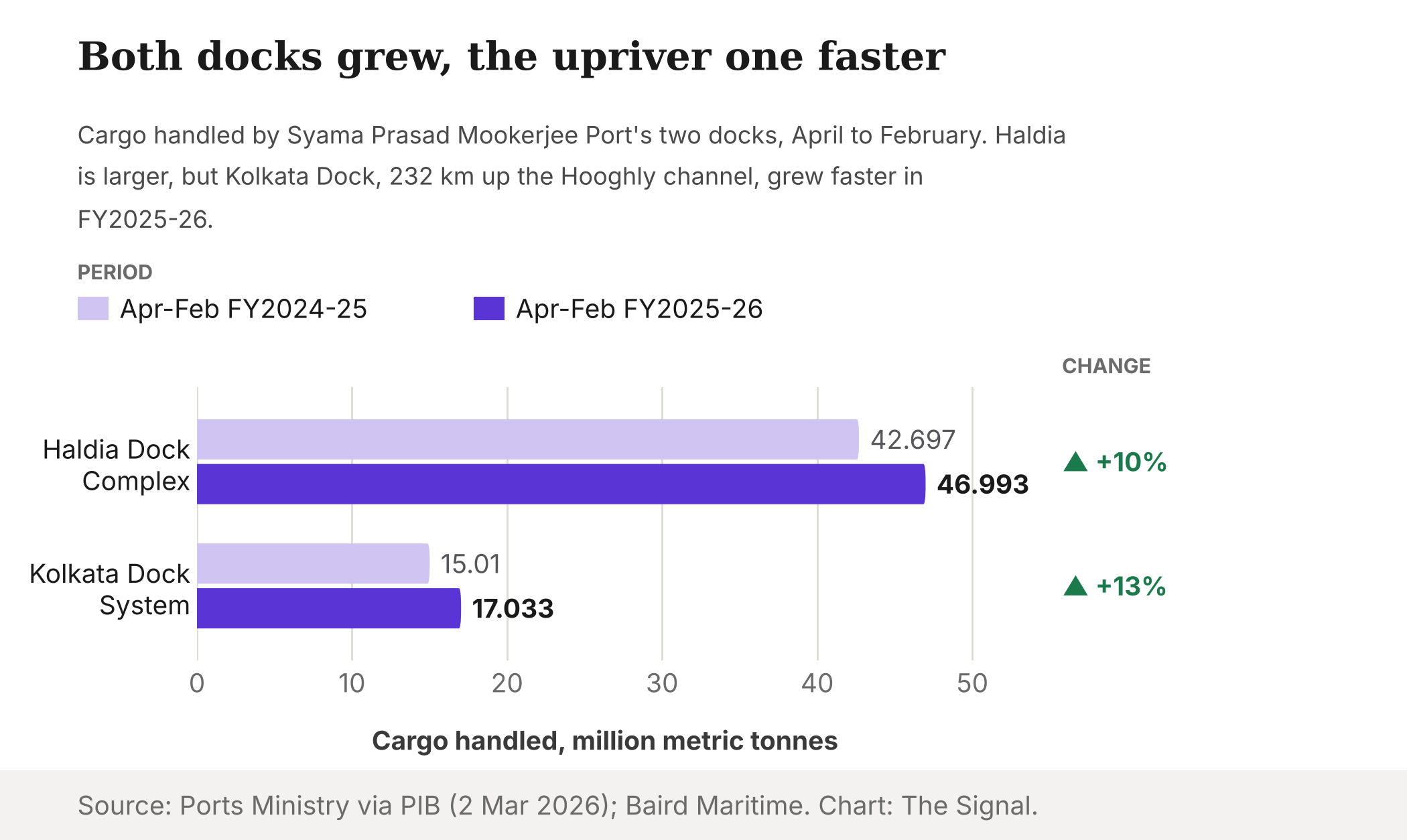
Haldia carries most of the cargo, but the upriver dock is the one growing faster.
| Dock | FY2025-26 cargo (million tonnes) | Share of port, FY2025-26 | Growth, FY2025-26 | April-July 2026 cargo (million tonnes) |
|---|---|---|---|---|
| Haldia Dock Complex | 51.86 | about 73% | 9.6% | 17.28 |
| Kolkata Dock System | 18.84 | about 27% | 13.2% | 6.42 |
| Syama Prasad Mookerjee Port, total | 70.70 | 100% | n/a | 23.70 |
Source: Ministry of Ports, Shipping and Waterways, April-March 2025-26 (advance estimates) and April-July 2026-27.
The trend does not point downriver. The same ministry figures show the Kolkata dock growing 13.2% in 2025-26 against Haldia's 9.6%. A ministry release via PIB on 2 March 2026 put the April-February numbers at 17.033 million metric tonnes for the Kolkata dock (up 13.48%) and 46.993 million for Haldia (up 10.06%). The latest ministry table, for April-July 2026, shows the port at 23.70 million tonnes, roughly flat on a year earlier, with the 73:27 split unchanged.
Haldia is also not off the river. Both docks sit on the Hooghly estuary. Baird Maritime reported on 27 October 2026 that the port authority maintains about 232 kilometres of channel to the Kolkata dock and 125 kilometres to Haldia, and that its dredging bill for 2024-25 and 2025-26 came to ₹7.64 billion, of which the Centre approved ₹4.31 billion.
The honest objection
The strongest case against this reading is that hydrology changes nothing about the politics. The treaty is an allocation rule, and allocation rules exist precisely to divide shortfalls. Whatever the monsoon does, India operates the barrage, Bangladesh does not, and the side with the gate negotiates from strength. On this view the drier river only raises the value of India's leverage.
That case is right about who holds the gate. It is wrong about what the gate can deliver. The treaty's guarantee is a promise of 35,000 cusecs to whichever side's turn it is, drawn against a schedule of 1949-88 averages. The PNAS reconstruction says the three decades after 1990 were the driest in 1,300 years, mainly because of rainfall. Leverage over a smaller flow is leverage over the right to absorb a shortfall. India's own need is not shrinking either: the Kolkata dock grew fastest in 2025-26, per the ministry data, and Bihar wants more water than enters its border in the lean months, per the state board document.
The treaty's own ledger is the hardest test of this reading. An analysis of Joint Rivers Commission records by Shafiqul Islam, a Tufts University professor, published in The Daily Star covers all 450 ten-day dry-season periods from 1997 to 2026. Recorded availability at Farakka fell below the 50,000-cusec consultation threshold only once, in 21 to 31 March 1997, and releases to Bangladesh show no shortfall above 1 cusec after 2003. On paper, the guarantee has been kept. The same analysis finds no statistically significant trend in availability over those thirty years, though the 2007-2016 decade ran about 8% below the decades on either side.
That record is a real point for the treaty, and it should temper any claim that the guarantee is already failing. It does not settle the hydrology. The Daily Star analysis itself cautions that availability at Farakka is an accounting quantity, the sum of the two releases, rather than an independent measurement of the river. And the treaty was signed in 1996, inside the 1991-2020 stretch that the PNAS reconstruction ranks as the driest in 1,300 years, so a flat record within that stretch is consistent with a river that sits low throughout rather than one sliding lower. What thirty years of ledgers show is that the formula has been delivered in a dry era. Flows below 50,000 cusecs, where the formula would be strained, have almost never been tested.
There is a fair objection from the other direction too. Upstream pumping is a real contributor, and India could in principle manage it. But the PNAS authors rank it second to the monsoon, so even an India that cut withdrawals would not restore the river the 1996 schedule describes.
The Signal
The Ganga treaty is usually told as a story about two governments and one barrage. The figures tell a story about three claimants and a smaller river. Bangladesh wants its guarantee, India wants water for a port whose upriver dock is still growing, and Bihar wants more than reaches it, all drawing on flows that a peer-reviewed reconstruction calls the driest in 1,300 years for 1991-2020. Watch what any successor deal does with the numbers. If it copies 35,000 cusecs and the 1949-88 schedule, it renews a promise sized for a different river. If it rebuilds the schedule on post-1990 flows, or resets a 50,000-cusec consultation trigger that, on Joint Rivers Commission records, has fired once in thirty years, it is pricing the river that exists. A treaty can fix a share. It cannot fix the flow.
Reporting basis: the treaty's sharing formula, its 1949-88 indicative schedule, the 50,000-cusec consultation clause and its thirty-year term are from the 1996 treaty text as held in the Asian Development Bank's legal repository. The Dhaka meeting and the renewal's absence from the agenda rest on a single report, ThePrint's, citing government sources. The barrage's purpose is per the Farakka Barrage Project, as reported by The Week. Port cargo figures are the Ministry of Ports, Shipping and Waterways' major-port statistics, with the April-February 2025-26 dock figures from the port authority via a ministry release on PIB; the FY2025-26 numbers are advance estimates. Dredging costs and channel lengths are per Baird Maritime and rest on that single outlet. The 1,300-year streamflow reconstruction is from Chuphal, Thirumalai and Mishra in PNAS (2025), and the baseflow estimate from Mukherjee, Bhanja and Wada in Scientific Reports (2018). The thirty-year record of ten-day releases at Farakka is from Joint Rivers Commission data as analysed by Shafiqul Islam in The Daily Star; The Signal did not independently check the commission's tables. The Bihar flow figures are from a Bihar State Pollution Control Board document, as reported by Mongabay-India. India's residual share in late April, the ratio of Bihar's demand to the flow at Chausa, and the dock growth comparison are The Signal's calculations from those figures.